Wednesday, October 22, 2008

Half Moon Bay CA


Date: 10/22/2008
Location: Half Moon Bay
Lat/Lon: 37°30.116'N 122°28.989'W
Weather: Sunny & Warm, 70° @ 7 AM, 85° @ 2 PM

We left Pier 39 in SF Sunday at 9 AM and had a nice cruise down the coast 20 miles to Half Moon Bay. Weather forecast was for winds 15-25 for most of the week so we decided to take a slip in the marina rather than anchor out although there is plenty of good anchorage within the outer breakwater. We also had our mail forwarded to the Harbormaster from Anacortes because we wanted to make sure that we would get our ballots in time to vote. As it turned out the weather the first part of the week was milder than forecasted and we could have easily gone on but once we ordered the mail we were stuck waiting for it to arrive.

Luckily, Half Moon Bay has a beautiful marina with newer docks and a lovely setting. The downside is that the nearest shops are 4 miles in the town, all that's around the marina are restaurants, hotels, and fishing charter businesses. The beach that runs from the north end of the bay, where the marina is located, to the town 5 miles to the south is a beautiful southern California beach and it's a park so you can walk the entire length. We walked a couple of miles before turning back. It's nice to be in a warm area, I actually washed the boat today in shorts, t-shirt, and bare feet. We don't miss the cold and damp of the PNW at all.

The mail arrived today, Wednesday, so we'll be off at first light tomorrow for a 9 hour cruise to Monterey. A front is passing over Friday & Saturday so it looks like we'll be in Monterey for 3 or 4 days waiting for the seas to lay down.

Walkin' on water -

Monday, October 20, 2008

San Francisco


Date: 10/13/2008
Location: Pier 39 Marina, San Francisco, CA
Lat/Lon: 37°48.514'N 122°24.515'W
Weather: sunny

We came under the Golden Gate today, on our own boat! We had planned to go to Sausalito but the only slip we could find there had 220 VAC and we have 120 VAC on the boat so we came to the Pier 39 East Marina on Fisherman's Terminal in San Francisco. Our slip there had a strong current running through it with ocean surges combined with large tour boat wake so the boat moved around like we were in a storm on the ocean with the lines tugging and moaning as we move back and forth and up and down. All this movement made us feel slightly nauseated whenever we were on the boat. But it could be worse, in the marina right next to us, the Pier 39 West Marina, they have more surge from the swells and have over 300 sea lions on the docks, barking and stinking up the place. No thanks. If you visit SF on your own boat, do not go to the Pier 39 West Marina. The smell alone will drive you out of the place.


Pier 39 looks like it came right out of Disney. Dozens of shops and restaurants, everything from the Hard Rock Cafe to Buba Gump's Shrimp to an NFL Football shop. Crowds of people everyday from opening at 10 AM until the late evening. We heard that Pier 39 attracts the 3rd largest number of tourist of any place in the US (Disney's two places being 1st and 2nd). The original Fisherman's Wharf is down the waterfront a few blocks and still looks authentic.

We played tourist for 6 days here walking the entire Fisherman's Wharf area multiple times, taking a city tour on a double decker bus, going to China Town to look around and had lunch in a good Chinese restaurant (Chinatown Restaurant). SF is a fun place to play tourist but the crowds and noise will sap your energy if you're not use to it plus with our boat rocking and rolling all night long due to the tidal surge and boat wakes, we never did get a good nights sleep while moored there.


On Saturday Linda's brother Kent drove into town from his home in Grass Valley (3 hours one way!) and spent the afternoon visiting. We had lunch at Louis Italian Restaurant on Pier 39 (bad service, bad food, thumbs down) but had a good visit.

Sunday, October 12, 2008

Bodega Bay Photos

Date: 10/12/2008
Location: Bodega Bay
Weather:Sunny 70°, winds 5-10 kts

We went for a long walk to Bodega Head at the end of the bay and looked out over the ocean. We both like Bodega Bay because it's the first place we've been on this journey where it feels warm and the sky and waters are blue. Here's a few pictures from our walk.

Looking north from Bodega Head -


A deer we came upon in the Biological Reserve part of Bodega Bay.

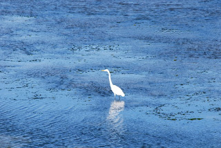
Great Egret. Notice the deep blue color of the water. Water tempature in the bay is 58°F.

White Pelicans -

Thursday, October 9, 2008

Bodega Bay CA

Date: 10/7/2008
Location:Bodega Bay CA
Lat/Lon: 38°19.801'N 123°03.460'W
Weather:windy N 15-20 kts, sunny, 65 F

There was a 1 1/2 day window of good weather before the next front arrived so we left Fort Bragg in the late afternoon on Monday and did another overnighter to Bodega Bay. The NOAA weather forecast again understated the winds and we spent the night surfing in a following sea of 8-12' waves with the wind blowing NNW 25-30 kts. It's not as uncomfortable as pounding into the waves and once you get use to the motion of the waves overtaking and then passing under the boat, it was an ok ride. The swells were coming from our starboard (right) aft quarter so when a swell would overtake us the aft of the boat would rise up and be pushed to the port (left). As the swell passed under the boat the aft lowers and moves down the backside of the wave to the starboard as the bow rises. Our 46 Nordhavn has a very round bottom so her motion is smooth, not snappy like flatter bottom boats. She does move around a lot so in larger seas above 4' you need to get in sync with the motion and always have one hand holding on. After each passage, Linda and I both have sore muscles in our legs and waist from the constant motion and the body's natural instinct to fight against it.

Bodega Bay looks like southern CA, low brown hills, round, bushy trees and blue sky. For the first time it seems that we've finally reached a different area of the coast. The marina is relatively new and it doesn't smell of rotting fish like many of the fishing ports we've been at on the coast. There is a small town on the other side of the bay that we can walk to to get some groceries and do some shopping. Everyone has seen Bodgea Bay, they just may not know it. This is the location where Hitchcock filmed 'The Birds', not in New England.

There is a big front moving down the coast over the next few days with high winds and seas, so it looks like we'll be here at least through the weekend and that's ok with us. With the market falling like a rock, Bodega Bay is a nice place to go broke.

Wednesday, October 8, 2008

Pleasant overnighter from Eureka to Fort Bragg


Date: 10/1/2008
Location: Fort Bragg CA, Noyo River Basin
Lat/Lon: 39°25.440'N 123°48.082'W
Weather: High clouds, lite wind

We departed Eureka marina at 11:30 AM after a good (12 hour) night sleep. There was calm winds and sun as we motored out the channel against the flood tide. The bar was calm and we took a heading to go around Cape Mendocino, the most westerly cape on the lower 48 except for Cape Flattery which we rounded on August 31st. The seas built to 3-5' off of the cape but quickly flattened as we rounded the cape and headed south. We had a southerly current so we slowed the engine to 1250 RPM and still maintained over 5 kts. Fort Bragg is 100 south of Eureka, Humboldt Bay, which would take 15.5 hours at our normal cruising speed of 6.5 kts but we again were constrained by the currents in the bar. Humboldt Bay flooded until 1:15 PM and the flood in Fort Bragg started at 7:30 AM the following morning so we had nearly 18 hours to cover the 100 NM for an average speed of 5.5 kts. Added to the equation is that we wanted to get around Cape Mendocino, which has a reputation as being quiet nasty, in the daylight. Our plan was to leave early from Humboldt Bay to make the flood and hurry, if you can call 6.5 kts hurrying, around the Cape and then slow down for the remainder of the trip and arrive at Fort Bragg at day break.

On this trip the weather cooperated and was as forecasted so we had a nice overnight voyage. In the early morning I was getting very sleepy so I laid down at 6 AM for an hour and when Linda woke me she said it was a nice morning but the swells were very large. What we saw when the sun came up was swells up to 15' tall but over 15 seconds in duration so it was very gentle ride as we rode the swells up and down. We called the CG and they reported that the bar and channel had 2-4' swells and there were no restrictions so we proceeded in. The CG also asked for our boat name, description, documentation number, number of people on board, number of life preservers, and our GPS position. We pulled the stabilizer fish out of the water at the outer buoy and proceeded in. The channel is very narrow and turns sharply after you pass under the Highway 1 bridge and other than being temporarily blinded by the rising sun, we had a good trip across the bar and through the narrow channel. Once inside the channel we pulled up the paravane arms and made our way to our slip in the basin. The basin has narrow fairways and the finger piers are no longer than 40' so getting a 48' boat in was a bit of a challenge but there was no wind or current.

There is no wifi in the basin but there is wifi further up the river 1/2 a mile at a small boat basin that has a RV park. We use the SSB radio and SailMail.com to get text email and download weather forecasts. To get to a store we have to walk a mile up a steep hill but there's a nice shopping center and grocery store at the top. There is a winter weather pattern developing with high winds and seas so we might be here for a week or more waiting for good weather. Such is the life of cruisers trying to make their way down the coast. We hope that when we get below San Francisco the weather will improve and become more stable.

The over night trip from Hell.

The plan was to leave late in the afternoon today and cruise all night arriving in Eureka for the flood tide at 8 AM. The trip is 72 NM which will take 12 to 13 hours and we want to leave CC in daylight so that will make us 2 hours early arriving in Eureka. We'll just 'hang out' off the bar to Humboldt Bay until sun rise at 7 AM and then we'll call the CG and find out the bar conditions and if everything is ok, we proceed in. It's 72 NM from CC to Eureka and flood tides this week are occurring in the morning so we needed to arrive in the morning hence the overnight trip. The weather forecast was for winds SSW 5-10 kts so we were looking forward to an easy trip.

We departed CC at 5 pm in 5 kt winds and had a route laid out that would take us 15 NM offshore so we wouldn't have to worry about crab pots. Once we were offshore we turned south as the sun went down. At 10 PM I went to lie down and Linda was on watch. Around midnight I was awaken by the boat pounding into waves and I came up to the pilothouse to see how Linda was doing. We were off Trinidad Head (41°02.910'N 124°19.800'W) and the wind and seas had started building over the last hour, the wind was now SW 20-25 kts and the seas seemed to be steep and 6-8' in height. We reduced the engine by 100 RPM and that somewhat eased the motion of the boat. I decided to stay up and see how things developed, plus I wouldn't be able to sleep with all this going on. At night it is very difficult to tell what the waves look like, how high and steep they are, but we could see white foam on the wave tops and we were taking spray over the bow.

In the next hour the wind continued to increase and the seas were building and Linda started to feel seasick. Quickly she progressed from feeling a little queasy to violently vomiting in the aft head. She was very sick and spent the rest of the night either kneeling in front of the head or lying in the passage way outside of it. I remained on watch as the seas built and the winds reached 40-45 kts and the sea became very steep and over 12' high. The boat was taking spray over the pilothouse as she pounded into the waves yet the boat was handling it well and although we were uncomfortable, especially Linda, we were in no danger. I continued to reduce the engine speed trying to ease the pounding with little effect. Our main concern was what would we do if we could not get across the bar at the Humboldt River and into Eureka. The next port was Fort Bragg 100 NM further down the coast and we didn't want to continue like this for another 16 hours.

By 6 AM we were off of Humboldt Bay and the seas and winds had come down as we came closer to shore. We're not sure if the high winds we experienced were caused by a passing front that was heighten by Trinidad Head or was just an off shore disturbance and had we been closer to shore we would not have had the high winds. Whatever the cause, as we approached the shore off of Eureka the wind died down to 10kts and the seas to 3-4'. We still had an hour to sunrise and 2 hours to the flood on the bar. We cruised 3 NM past the bar entrance and turned around with the seas coming from behind us and the boat motion calmed way down and Linda started to feel much better. I called the Coast Guard and they reported 2-4' swells in the bar entrance with no restriction. We easily crossed the bar and once in the channel pulled up our paravanes and made our way up to the marina on Woodley Island across from town. Once tied up at the dock and registered we both collapsed in bed for 4 hours, safely secured to a dock. That night we both slept for over 12 hours, recovering from the rough night.

In the morning we both felt refreshed and decided to continue onto Fort Bragg. The marina at Woodley Island in Eureka had little to offer other than a nice restaurant but it was a long distance to any shops in town so we decided to continue while the weather was good.